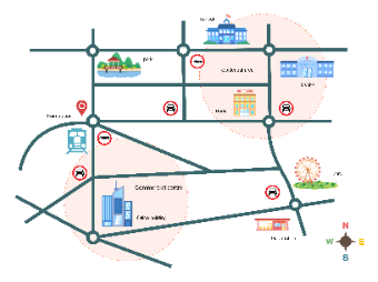
This template offers a well-organized city map layout, highlighting essential locations such as schools, parks, residential areas, hospitals, commercial centers, and more. The design also includes important transport routes and stations like the train station, bus stops, and a gas station. Each key location is represented with icons for easy identification, and transport restrictions are marked with signs. This layout can be used for city planning, real estate presentations, or providing a guide for visitors to understand the city's infrastructure and amenities. The map also includes a compass for directional orientation, making it a comprehensive visual aid.


 Desktop