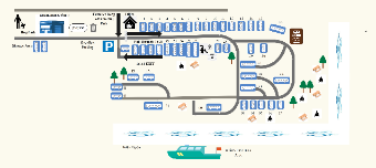
This is a graphical representation of a recreational park's map, detailing various facilities and camping spots. The layout indicates an office area at the entrance, followed by sequentially numbered camping spots that wind through the park. Notable features include a designated dog park, maintenance shop, storage area, and a propane supply point. There is a section labeled 'Pull Through 18-21' for specific campsite access, accompanied by an exit route. To the right, amenities such as a dump station are marked. The bottom portion of the map illustrates Turtle Bayou adjacent to which is White's Park Boat Dock, suggesting water-based activities. The overall design is functional, guiding visitors through the park's infrastructure and recreational zones.


 Desktop