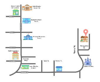
This is a stylized map focused on a specific urban area within Davao City. It features a network of streets and identifies various landmarks such as government buildings, educational institutions, residential areas, and a place of worship. The map uses icons and labels to clearly denote each landmark, providing a quick reference for locating these sites within the city. It is a valuable tool for anyone needing to understand the layout of this part of the city, whether for daily commuting, emergency services, or urban planning.


 Desktop