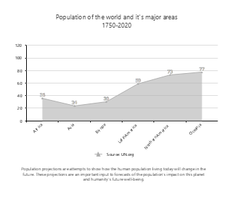
This area chart template for the analysis of population changes in major regions of the world is designed for scenarios such as demographic research reports, geography teaching courseware, sociological data analysis, and academic paper visualization, serving as a professional data visualization tool in the field of population statistics. Adopting the area chart type, the template intuitively presents the population data distribution of six major regions: Africa, Asia, Europe, Latin America, Northern America, and Oceania, paired with a population projection description module at the bottom to clearly show the population size comparison and growth trends of different regions. Demographic researchers, geography teachers, sociological researchers, and students can directly use EdrawMax to quickly edit the template, replacing data, adjusting color schemes, and modifying text to adapt to various scenarios such as world population development trend research, regional population difference analysis, population forecast report production, and classroom teaching data display. Without designing charts from scratch, users can efficiently complete professional reports and teaching presentations, helping to clearly present the characteristics of population data and enhance the professionalism and persuasiveness of academic analysis and teaching displays.


 Desktop